Every year, in Nepal’s Banke National Park, hundreds of wild animals are killed trying to cross a single stretch of road. This road, just under 60 miles long, cuts through the heart of the park. From April 2015 to March 2024, scientists including WaNPRC’s Randy Kyes, Unit Chief of the Global Conservation Education and Outreach core, closely monitored this road and recorded 488 collisions between vehicles and wildlife. Most of the victims were mammals, including rare or endangered animals like golden monitor lizards, leopard cats, and four-horned antelope. These incidents aren’t just tragic for the animals; they also pose serious safety risks for drivers and come at a steep economic cost.
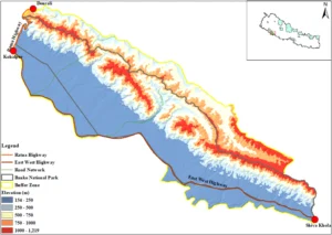 The researchers didn’t stop at counting the accidents. They wanted to understand where and why they were happening. Using maps, field surveys, and computer models, they identified three major danger zones on that road. These hotspots were responsible for more than 60% of all wildlife collisions. They also learned that accidents happened more often in the autumn, when animals are more active after the rainy season. And they discovered that curvy roads and sections far from human settlements saw the most accidents, while areas that ran through denser forests or had straighter paths tended to be safer for both animals and people.
Kyes and the other scientists published a paper in Nature summarizing their findings in a call to action. The study shows that with the right measures, like building wildlife overpasses, putting up warning signs, lowering speed limits in key areas, and educating the public — these deadly accidents can be reduced, both protecting wildlife and making roads safer for everyone. The work done in Banke National Park offers a roadmap for how science and conservation can work together to create safer spaces for nature and humans alike.